


Boucle Roche du Mas

rigol05
User
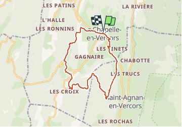

Length
14.6 km

Max alt
1296 m

Uphill gradient
624 m
Km-Effort
23 km

Min alt
825 m

Downhill gradient
623 m
Boucle
Yes
Creation date :
2018-08-01 12:51:41.075
Updated on :
2018-08-01 12:51:41.075
--
Difficulty : Unknown

FREE GPS app for hiking
 SityTrail
IGN / Geographical institutes
SityTrail Plus
The world is yours!
About
Trail Walking of 14.6 km to be discovered at Auvergne-Rhône-Alpes, Drôme, La Chapelle-en-Vercors. This trail is proposed by rigol05.
Positioning
Country:
France
Region :
Auvergne-Rhône-Alpes
Department/Province :
Drôme
Municipality :
La Chapelle-en-Vercors
Location:
Unknown
Start:(Dec)
Start:(UTM)
690562 ; 4982325 (31T) N.
Comments